Shared-use paths and sidewalks often look similar on the ground, but they are governed by different accessibility expectations, design assumptions, and legal frameworks. That distinction matters for cities, campuses, park agencies, consultants, and property owners because a path built for mixed bicycle and pedestrian travel is not evaluated the same way as a pedestrian route within the public right-of-way. In practice, I have seen costly redesigns happen because a project team labeled a route “trail” or “sidewalk” too casually during early planning, then discovered later that crossing treatments, curb ramps, width, running slope, and detectable warnings triggered a different standard. If you are responsible for planning, designing, reviewing, or maintaining these facilities, understanding which accessibility standards apply is the starting point for compliance and safer travel.
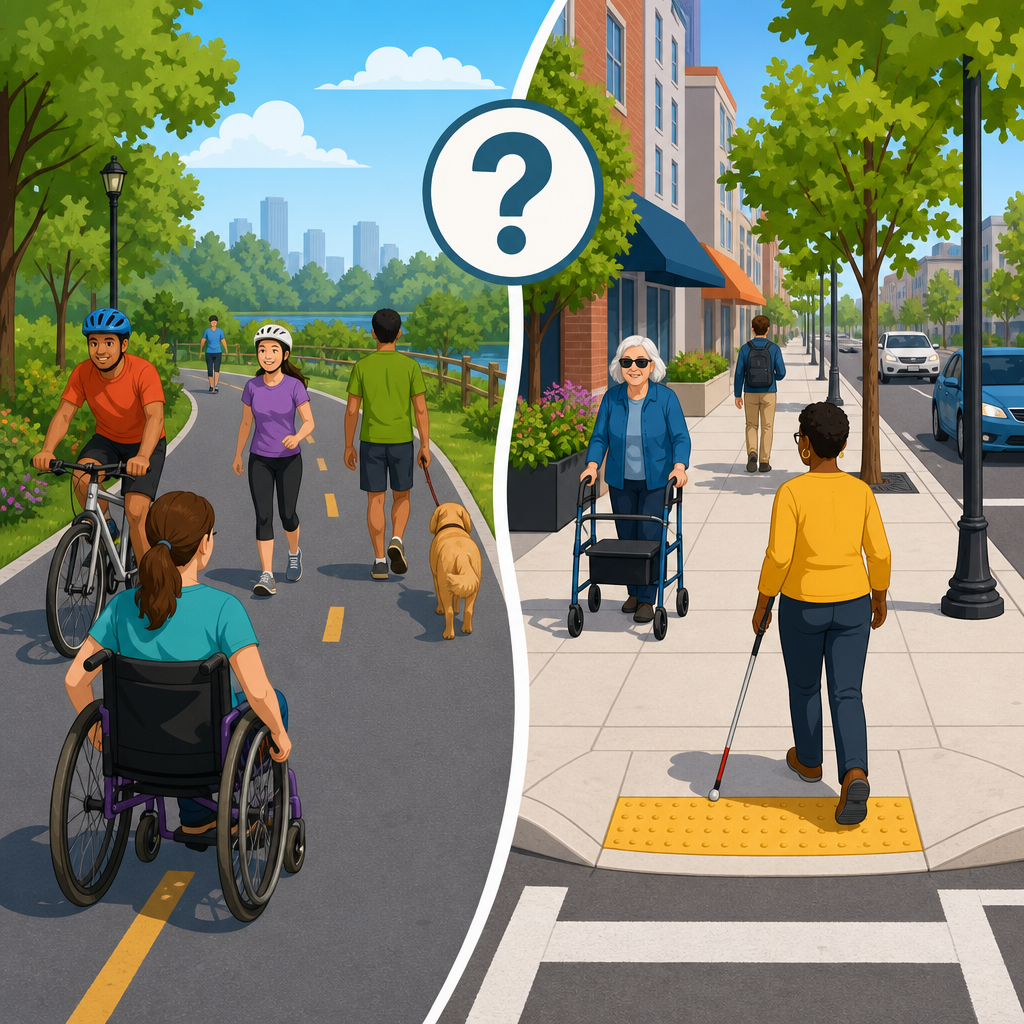
A sidewalk is generally the pedestrian route within a street corridor, usually separated from the roadway by a curb, planting strip, or shoulder, and tied directly to intersections, transit stops, driveways, and building entrances. A shared-use path is typically a circulation route physically separated from motor traffic and intended for both pedestrians and bicyclists, though skaters, wheelchair users, runners, and micromobility users may also rely on it. The accessibility question is not simply what the route is called on a plan set. The answer depends on where it is located, who controls it, how it functions, and whether it is part of the public right-of-way or a transportation facility outside that right-of-way. Those facts determine which standards, scoping provisions, and technical criteria should guide design and review.
This hub article explains how to classify sidewalks, curb ramps, street crossings, and shared-use paths; which federal accessibility standards are most relevant; where transportation guidance fits; and how to avoid common mistakes. It also serves as the entry point for the broader topic of sidewalks, curb ramps, and public rights-of-way, connecting the core issues that every related article builds on: pedestrian access routes, cross slope, grade, blended transitions, detectable warnings, accessible pedestrian signals, protruding objects, maintenance obligations, and transition planning. The goal is simple: make it easier to determine the right standard before design decisions become construction claims or barriers become civil rights complaints.
How to distinguish a shared-use path from a sidewalk
The clearest distinction is functional. A sidewalk primarily serves pedestrian access along a street corridor. It is part of the network people use to reach adjacent land uses, transit, intersections, and crossings. A shared-use path serves both transportation and recreation, usually accommodates bicycle travel by design, and is typically separated from motor vehicle lanes. Width is a clue but not a legal test. Many agencies use ten feet as a typical minimum paved width for a shared-use path, following transportation guidance, while a sidewalk may be much narrower depending on context, but a wide sidewalk does not automatically become a shared-use path.
Location matters just as much as function. If the route sits within the public right-of-way and operates as the pedestrian route alongside a street, the project team should analyze it as a sidewalk or pedestrian access route. If the route is outside the street right-of-way and intended for mixed pedestrian and bicycle circulation, agencies often evaluate it using accessibility provisions that apply to trails or outdoor developed areas only when it truly functions as that type of facility. In my experience, the most defensible approach is to document the route’s purpose, users, ownership, and network connections at schematic design, then confirm the applicable standard before grading and drainage are fixed.
Which accessibility standards usually apply
For sidewalks, curb ramps, street crossings, and other pedestrian features in the public right-of-way, the primary reference point is the U.S. Access Board’s guidance for public rights-of-way, commonly called PROWAG. Many transportation departments and local governments use it because it addresses the conditions sidewalk designers actually face, including constrained corridors, on-street parking, median refuges, roundabouts, and signalized crossings. Although adoption status can vary by jurisdiction and project type, PROWAG has become the practical benchmark for accessible design in streetscape work because it is tailored to public right-of-way conditions in a way building-site standards are not.
For facilities on sites and within buildings, the 2010 ADA Standards for Accessible Design remain the central federal standard. They are highly relevant when a pedestrian route is part of a site, park facility, campus, or building approach rather than the public street environment. Shared-use paths can fall into a gray area. Some agencies use the 2010 ADA Standards for certain site-connected segments, while also relying on transportation guidance such as the AASHTO Guide for the Development of Bicycle Facilities and the Manual on Uniform Traffic Control Devices for operations, markings, and crossing treatments. The Federal Highway Administration has also issued technical assistance that influences how agencies interpret accessible design for separated bicycle and pedestrian facilities.
The key point is that no single label resolves compliance. A path can require coordinated use of accessibility standards, transportation manuals, and state or local criteria. The best question is not “What do we call it?” but “What function does it serve, and which rules govern that function?”
Core accessibility requirements for sidewalks and curb ramps
Sidewalk design starts with the pedestrian access route, the continuous accessible path that people with disabilities must be able to use along the street corridor. That route must maintain adequate clear width, manageable cross slope, and a firm, stable, slip-resistant surface. Cross slope is one of the most common failure points I see in field reviews because drainage priorities often push designers toward excessive tilt. For pedestrian access routes, the target cross slope is generally 2 percent maximum, because steeper cross slopes create side-force problems for wheelchair users and can destabilize walkers or scooters.
Running slope on sidewalks follows the grade of the adjacent roadway in many public right-of-way conditions, which is why sidewalk rules differ from building ramps. If a street climbs a hill, the sidewalk may climb with it without becoming a ramp in the building-code sense. That said, landings, transitions, and connections still need careful design, especially at driveways and intersections. Driveway crossings are another frequent problem. A sidewalk should remain as level and continuous as possible across driveways; the driveway should ramp to meet the sidewalk, not force pedestrians into a sharp cross slope.
Curb ramps and blended transitions are required where a pedestrian route crosses a curb. The details matter: ramp runs, flares where pedestrians may walk across them, landing conditions, and placement relative to the crossing direction all affect usability. Detectable warning surfaces are also essential at curb ramp openings and blended transitions to alert blind or low-vision pedestrians that they are entering the vehicular way. Truncated domes must contrast visually with adjacent surfaces and be located precisely enough to provide useful warning without creating confusion.
| Feature | Typical sidewalk/public right-of-way expectation | Common design mistake |
|---|---|---|
| Pedestrian access route | Continuous clear path with compliant width and surface | Utility poles or cabinets narrowing the route |
| Cross slope | Generally 2% maximum | Over-sloping for drainage at driveways |
| Curb ramp | Aligned with crossing and connected to level transitions | Diagonal ramps serving two crossings poorly |
| Detectable warnings | Installed at street entry point with visual contrast | Placed too far back from curb line |
| Accessible crossing | Clear landing, proper signals where warranted, refuge access | Median cut off by inaccessible curb |
How shared-use path accessibility is evaluated
Shared-use paths should be accessible, but the technical approach can differ because bicycle operation changes geometry, speed, and conflict conditions. Width is usually greater than for sidewalks because users travel side by side, pass one another, and approach at different speeds. AASHTO commonly recommends ten feet as a standard paved width, with wider sections in higher-volume areas and lower widths only in constrained conditions. Horizontal clearance, stopping sight distance, and intersection control become central design issues because accessibility is not limited to slope and surfacing; it also depends on whether people can perceive and navigate conflicts safely.
Where a shared-use path intersects a street, the crossing design must work for both mobility and accessibility. Refuge islands must be reachable, pushbuttons must be located within accessible reach ranges where signals are used, and transitions cannot strand a wheelchair user in a median or at the edge of a crossing. Separated shared-use paths running parallel to roads can create especially tricky situations at side streets and driveways. Motorists may not expect two-way bicycle traffic or pedestrians set back from the roadway, so sight triangles, stop bar placement, and warning devices need careful coordination.
Surface quality is another major issue. On paper, asphalt may meet the requirement for a firm and stable surface, but field performance depends on installation quality, cracking, root heave, and maintenance. I have reviewed paths that were compliant at opening and meaningfully inaccessible within three years because ponding, edge drop-offs, or utility settlement were not addressed in the maintenance plan. Accessibility is not only a design standard; it is also an operations obligation.
Street crossings, signals, and other public right-of-way elements
The public right-of-way is more than the sidewalk itself. Compliance depends on the full chain of travel, especially at crossings. Marked crosswalks need accessible connections on both ends. Medians and pedestrian refuge islands must include cut-throughs or ramps aligned with the crossing path. Accessible pedestrian signals are required in many signalized contexts to provide audible and vibrotactile information to pedestrians who are blind or have low vision. The MUTCD and Public Rights-of-Way Accessibility Guidelines work together here: one governs traffic control devices and operational warrants, while the other addresses accessibility features and placement requirements.
Transit stops are another frequent weak link. A compliant sidewalk leading to an inaccessible bus boarding area does not create an accessible trip. Boarding and alighting areas need adequate dimensions, connections, and slope control, and the route from the sidewalk to the stop must remain unobstructed. Street furniture, signs, hydrants, and utility appurtenances also matter because protruding objects can create serious hazards for cane users. A corridor can fail accessibility review even when its paving looks new if these elements are placed within the circulation path.
Maintenance is often overlooked until complaints arise. Snow, debris, overgrown vegetation, broken panels, and temporary work zones can make a technically compliant sidewalk unusable. The ADA obligation is ongoing. Agencies need inspection cycles, work-order response standards, and temporary traffic control practices that preserve pedestrian access during construction. The strongest programs treat maintenance as part of accessibility management, not a separate public works issue.
Common compliance mistakes and how to avoid them
The most common mistake is using building-site standards alone for street projects. That leads to misapplied ramp rules, incorrect assumptions about sidewalk grade, and details that do not account for real intersection geometry. Another mistake is relying on standard drawings without checking field fit. A curb ramp detail can be technically sound in the abstract and still fail when drainage inlets, skewed crossings, or narrow rights-of-way distort the geometry. Field verification matters.
Agencies also get into trouble when they classify a corridor path as recreational to avoid stricter street-access requirements. If the route functions as a transportation link to schools, transit, businesses, or neighborhoods, reviewers and courts are likely to focus on actual use, not convenient labeling. The safer practice is to design for the most relevant accessible transportation function the route serves.
Finally, do not underestimate documentation. Keep records of design decisions, constraints, pedestrian circulation plans during construction, and maintenance responses. Good records help show that accessibility was considered systematically and can reduce risk when conditions are constrained or phased improvements are necessary.
How this hub fits the broader sidewalk and public right-of-way topic
This article is the hub for sidewalk, curb ramp, and public right-of-way accessibility because these elements operate as one connected system. The deeper articles under this topic should examine pedestrian access route width, cross slope measurement, curb ramp layout options, detectable warning specifications, accessible pedestrian signals, driveway crossing design, transit stop accessibility, maintenance responsibilities, and transition planning in detail. Start with classification: determine whether your route is a sidewalk in the public right-of-way, a shared-use path, or a site path. Then apply the standards and guidance that match the facility’s actual function.
The practical takeaway is straightforward. Sidewalks and curb ramps in the public right-of-way are usually evaluated through the lens of public right-of-way accessibility guidance, while shared-use paths require a coordinated approach that blends accessibility rules with transportation design guidance. Misclassification leads to bad details, poor usability, and legal exposure. Correct classification leads to better crossings, safer grades, clearer maintenance priorities, and a network more people can actually use.
If you are planning a corridor, updating standard drawings, or auditing an existing route, review each segment from the user’s perspective and verify the applicable standards before design advances. That step saves time, protects budgets, and produces streets and paths that work in the real world.
Frequently Asked Questions
What is the difference between a shared-use path and a sidewalk from an accessibility standards perspective?
A shared-use path and a sidewalk may appear similar in the field, but they are typically treated very differently when accessibility standards are applied. A sidewalk is generally understood to be part of the pedestrian circulation system within the public right-of-way. It is closely tied to streets, intersections, curb ramps, pedestrian crossings, transit stops, and the broader network of pedestrian access routes. Because of that role, sidewalks are usually evaluated using accessibility requirements associated with the public right-of-way, including expectations for pedestrian access, street transitions, crossings, and related features.
A shared-use path, by contrast, is usually intended for mixed travel, often including both pedestrians and bicyclists, and sometimes other permitted users such as skaters or micromobility devices depending on local rules. These paths are commonly found in parks, greenways, campuses, utility corridors, and transportation trail systems. Their design assumptions are different: they tend to be wider, they may operate with fewer street crossings, and they are not automatically treated as the same type of pedestrian route as a sidewalk simply because people can walk on them.
From an accessibility standpoint, the key issue is not what the route looks like, but how it functions, where it is located, and what legal framework applies to that type of facility. Misclassifying one as the other can trigger the wrong design criteria, documentation, and review approach. That is why project teams should not rely on labels casually. The route’s purpose, user mix, jurisdiction, connection to the public right-of-way, and governing standards all matter. In real projects, this distinction can affect width, grade treatment, cross slope assumptions, transitions, detectable warnings, intersection details, and how compliance is ultimately judged.
Which accessibility standards usually apply to sidewalks, and which usually apply to shared-use paths?
Sidewalks are commonly associated with accessibility requirements that govern pedestrian facilities in the public right-of-way. In practical terms, that means designers often look to standards and guidance that address pedestrian access routes, curb ramps, blended transitions, crosswalk connections, sidewalk width and passing space, and the relationship between the sidewalk and adjacent street features. These requirements are shaped by the fact that sidewalks are part of the public street environment and must connect people reliably through intersections, driveways, signals, and transit access points.
Shared-use paths are more often evaluated under accessibility frameworks used for trails, outdoor developed areas, site circulation, or other non-sidewalk pedestrian routes, depending on where the path is located and how the facility is classified by the responsible agency. However, there is no universal shortcut rule that says every off-street route follows one single standard. The applicable criteria may depend on whether the path is in a park, on a campus, as part of a transportation corridor, on federal land, or on private property covered by accessibility obligations. In some cases, multiple regulatory concepts may overlap, especially where a path intersects streets, leads to buildings, or serves as a required accessible route to a facility.
This is why teams need to identify the governing authority early. A city public works department, state DOT, campus owner, parks agency, or private developer may each approach classification differently, and the applicable legal obligations may not be identical. The safest approach is to determine the facility type first, then confirm which accessibility standards, agency policies, adopted guidelines, and funding-related requirements apply. That front-end analysis is far less expensive than redesigning a path after permitting or construction because the wrong standard was used from the start.
Why does mislabeling a route as a “trail,” “path,” or “sidewalk” create costly accessibility problems?
Mislabeling matters because accessibility compliance is not based on casual terminology; it is based on the actual nature and function of the facility. If a team calls something a “trail” to suggest more flexibility, but the route really operates as an essential pedestrian connection in a developed environment, reviewers may determine that more stringent pedestrian access expectations apply. On the other hand, if a mixed-use corridor is casually called a “sidewalk,” the design team may force it into a framework that does not fit how the facility is intended to function, which can create conflicts in width, operations, geometry, and user accommodation.
These mistakes often become expensive because the wrong classification affects decisions very early in design. Cross slope, running slope treatment, clear width, edge protection, intersections, curb ramp details, resting intervals, signing, striping, and transitions can all be influenced by the standard the team believes applies. Once plans are advanced, bid, or built, changing those elements can mean redesign fees, change orders, construction delays, and disputes among agencies, consultants, and contractors. It can also expose owners to complaints or legal risk if the completed route does not provide the required level of accessibility.
Another common problem is internal inconsistency. The civil drawings may call the route a shared-use path, the landscape sheets may label it a sidewalk, and the narrative in the permit set may describe it as a recreational trail. That inconsistency invites review comments and can undermine the rationale for design decisions. Clear classification, consistent terminology, and early documentation are essential. A short memo explaining why the route is being treated as a sidewalk, shared-use path, or another facility type can prevent major downstream problems.
How can a project team determine whether a route should be designed as a sidewalk or a shared-use path?
The best way to make that determination is to start with function, not appearance. Ask who the route is for, how it connects to the surrounding network, whether bicyclists are expected or permitted to use it, whether it sits within the public right-of-way, and whether it serves as a primary pedestrian access route along a street or as a separate corridor for mixed travel. A route immediately adjacent to a roadway and intended primarily for pedestrian movement through an urban corridor will often be treated very differently from a wider off-street route designed for both bicycle and pedestrian circulation.
Context also matters. On a campus, in a park, or along a greenway, a path may serve both transportation and recreational purposes. In those cases, the team should look carefully at ownership, permitting authority, adopted local standards, and whether the route is connecting to buildings, parking, transit, or public streets in a way that creates additional accessibility obligations. Intersections are especially important. Even if a route is generally treated as a shared-use path, the points where it meets streets, sidewalks, transit stops, or site access routes may require design responses that align with pedestrian accessibility expectations.
It is also smart to confirm the classification in writing with the owner or authority having jurisdiction before design advances too far. That can include a basis-of-design memo, meeting notes, or a formal interpretation if needed. The goal is to create a record showing why the route is being classified a certain way and which standards the team intends to use. That documentation helps align engineers, landscape architects, accessibility consultants, reviewers, and contractors. It also reduces the chance that someone later reclassifies the route during plan review or construction, when changes are more disruptive and expensive.
What are the most common accessibility design issues that arise when shared-use paths and sidewalks are confused?
One of the most common issues is width. Shared-use paths are often expected to accommodate two-way bicycle and pedestrian travel, which generally calls for more operating space than a standard pedestrian sidewalk. If a mixed-use facility is designed too narrowly because it was treated like a basic sidewalk, user conflicts and safety concerns can result, even if certain accessibility dimensions appear acceptable on paper. The opposite can happen too: a route may be oversized and geometrically configured like a path, but still fail important sidewalk-related accessibility details where it functions as part of the public pedestrian network.
Grade and cross slope are another frequent source of trouble. Sidewalks in the public right-of-way are often scrutinized closely because they are part of the core accessible pedestrian system, especially at driveways, curb ramps, and street crossings. Shared-use paths may involve different terrain conditions and design assumptions, but that does not mean slope issues can be ignored. Teams sometimes assume a path classification gives them broad flexibility, only to discover that portions of the route serve an essential accessible connection and are being evaluated more strictly than expected.
Transitions and crossings are also major problem areas. Where a shared-use path meets a street, parking area, sidewalk, or building entrance, the accessibility requirements at that transition can become more complex than on the path itself. Detectable warnings, curb transitions, refuge areas, and alignment details may all come into play. In addition, signage and operational assumptions can affect whether a route is truly functioning as mixed-use or primarily pedestrian.
Finally, one of the biggest issues is incomplete coordination among disciplines. Accessibility is not resolved by one note on one sheet. The classification decision needs to be reflected in planning documents, civil geometry, landscape plans, traffic details, specifications, and owner standards. When the label changes from one document to another, the built result often contains mismatched details. That is exactly how projects end up with expensive rework. The most successful teams treat route classification as an early compliance decision, not a drafting label added at the end.